Sunday, 15 March 2015
5 kilometer
Jenny and I did the Shamrock 5K walk. It was pouring rain earlier, but was only drizzling for our 9:45am start. Had a couple of Widmer Hefs at the finish to counter the effects of the walk.
Monday, March 16, 2015
Saturday, March 14, 2015
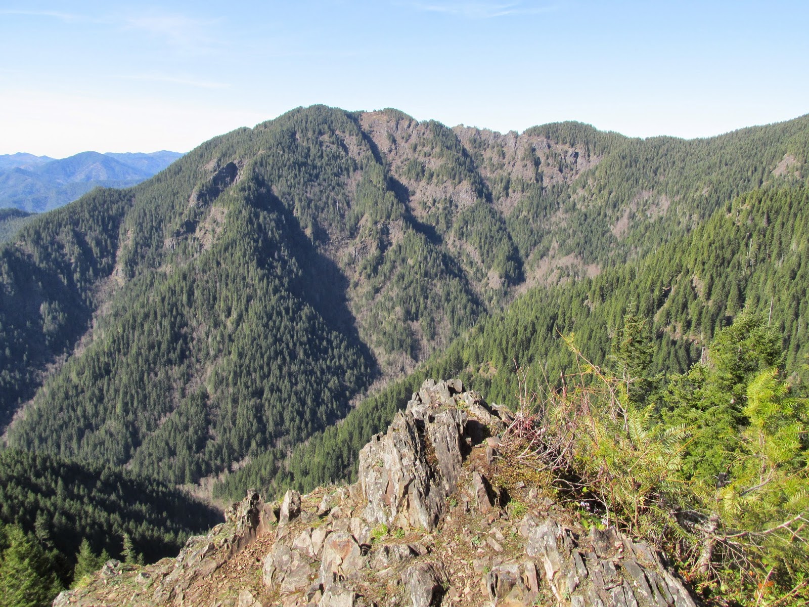
Elk Mountain / King's Mountain Loop
Saturday, 07 March 2015
7.2 mile day hike (me, TJ and Terri)
Wow, what a tough hike. I was not prepared for this one.
TJ, Terri and I took two cars. We parked my car at the Kings Mountain TH. We then drove and parked at the Elk Mountain TH. The Elk Mountain Trail gains about 1900 feet in 1.4 miles! We were huffing and puffing for sure. We started at about 9am and it was a little chilly, but we warmed up quickly. Trekking poles were worthless on the more steep sections where we were scrambling on all fours. Beautiful day and nice view at the top. Descending from the top is initially very steep, but then gets better. Once you get to the junction of the Elk and Kings Mountain trails, the "fun" soon begins again with steep ups and downs. There is even a section where the Mazamas have put a rope. Probably overkill, but I can see how this would be essential when the trail is wet. The last pitch up to the Kings Mountain summit is sublimely ridiculous. I was literally throwing my trekking poles up the trail, then scambling on all fours up the trail to retrieve them. After a rest and a snack, we headed down Kings Mountain. I have done this section before and it is steep too, losing 2500 feet of elevation in 2.5 miles.
Boy was I glad we took two cars. We avoided the 3.5 mile section of the Wilson River Trail which connects the Kings Mountain and Elk Mountain Trails.
TJ and Terri are in better shape than me and I'm afraid I held them back. We only averaged a little better than 1 MPH. TJ was smart enough to pack a beer cooler in the car and boy did that taste good. After that, we had dinner at Golden Valley Brewery on their dime. Life is good!
View of Kings Mountain from Elk Mountain summit
Descending the dreaded rope section
TJ, Terri and Reid atop Kings Mountain
TJ, Terri and Reid atop Elk Mountain
Saturday, January 24, 2015
Where Have I Been?
I thru-hiked the 165 mile Tahoe Rim Trail (TRT) on my two week vacation (Sep 6 to Sep 20). I hiked with a group of 12 hikers and 4 guides. I did this for safety, since this was my first long trek. But it turned out that the people were the best part of the hike. Even though it's hard to talk to people when you are strung out along the trail, you are all together in the evening in the "kitchen" and you form fast friendships. It was a great group of people and now that it is over, I miss my "trail family". I put together a twenty minute DVD slideshow which I mailed to everybody and I also posted a three minute YouTube video. The scenery was amazing and it just confirmed to me that I have chosen the correct "empty nester" avocation. My gear worked out great and I had the lightest pack of our group. People thought I was crazy, hiking in my 9.3 ounce Air Terra Kiger Trail Runners, but they performed admirably. I will admit that I had "tent envy" as I was cowboy camping or camping under my tarp. For that reason, I bought a cuben fiber Solomid XL tent from Mountain Laurel Designs. I expect to get it in the mail any day and I can't wait to try it out.
I have not hiked much since the TRT. Work has been busy, gearing up for a huge software "Winter Release". Now that I am done with this, I plan on slowly getting back into shape, so expect more regular blog entries in the future.
What is my next challenge? I'm not sure. Some candidates are the Wonderland Trail (93 miles) around Mount Rainier, the Timberline Trail (41 miles) around Mount Hood, the Mark O. Hatfield Trail (56 miles) from Multnomah Falls to Starvation Creek State Park. Eventually, I want to do the Colorado Trail, Pacific Crest Trail, Continental Divide Trail, etc.
.
Saturday, August 16, 2014
Timberline Lodge to Highway 35 and Back (10 miles) on Sunday, 10 August 2014
Since I am on-call at work for two-thirds of my life, only one of every three weekends can be a backpacking weekend where I am "off the grid". 9-10 August 2014 was supposed to be my hiking weekend, but we had a big Quarterly software release with "all hands on deck". Wouldn't you know it. But I managed to sneak in a day hike on Sunday.
I parked at Timberline Lodge and hiked down to Highway 35 (5 miles) on the Pacific Crest Trail. I saw 4 Mexico-to-Canada thru-hikers and talked to them briefly. The trail was steep at first and then much more gradual than I expected. I kept seeing these metal blue diamonds nailed up high in the trees, so naturally I thought "what in blue blazes ???". I realized they were marking the route taken in the winter by cross-country skiers, snowshoers, etc.
I stopped and had a snack at a picnic table next to Barlow Road. This was a geographical family reunion of sorts, since my Great Great Grandmother (Marianne Hunsaker D'Arcy) passed by here in a covered wagon in 1846. Here is an excerpt from her journal:
"As soon as Father and Mother, with their family, could safely leave the Company, East of the Cascade Mountains, they pushed on alone over the then new Barlow Road which passed over the South shoulder of Mt. Hood. Ours was the first wagon to come directly over it from across the plains. How well I remember what was to us, the children, the momentous task of getting the wagon down Laurel Hill. Ropes were tied to the wagon, and the other ends were snubbed around trees. Then Father, with the help of Mother and brother Horton, would carefully lower the wagon to where the horses could safely draw it again. It is still possible to walk up the old Barlow Road and see many of the trees marked by deep grooves made by the pioneers ropes."
On the hike back up, the trail turns sandy near timberline. I got lots of sand in my shoes since I was not wearing my gaiters. There is a neat stretch where you walk a narrow ridge, with the White River to the east of you and the Salmon River to the west of you. When I forded the Salmon "River" (which is no more than a trickle this high up), I drank my fill of untreated water, since I was near the end of my hike.
Monday, July 21, 2014
Lolo Pass to Timberline Lodge on the PCT (17 miles)
I parked at Lolo Pass at 4pm on Friday. Hiked until 8pm and called it a day next to the Sandy River. It looked pretty high and scary, so I decided to camp and check it out early in the morning.
On Saturday morning, as I stood next to the river, I enjoyed the antics of a couple of Harlequin Ducks. I think they were both hens. It was sunrise and all I could see were the white marks on their heads. They would stand on a rock, bob up and down, stare at me, then fly upstream and surf down the river before hopping out on the rock again. As I watched them cruise down the river, I decided to serenade them with a couple of verses of "Surfing USA". They flew away. I've never cared much for music critics, so I finished the song without them.
Crossing the river was challenging. It is swift and silty, so you can't see the bottom to tell how deep it is. I slowly worked my way out, feeling ahead of me with my trekking poles. The water was about 2.5 feet deep. That does not sound like much, but as a solo hiker, it was pretty freaky.
The uphill hike was uneventful. I took my time and hiked slowly since I did not plan on meeting my wife at the lodge until 4pm. After I got out of the river canyon, I had cell service, so I called my wife and told her that 1pm would be better. I had 286 unread emails on my work phone. Yikes! Glad I'm not on-call this week.
I passed many day hikers; especially after I crossed the Zigzag River. I was wearing long black pants, longsleeve black shirt (with my hood up) and black gloves. As you might guess, I am not a sun worshiper. I stay pretty cool since it is all Nike Dri-Fit. But a guy passed me and said "Wow, I'm hot just looking at you". I said "Thank you!" and continued on my way without turning around to see the look on his face.
I made it to the Lodge around Noon. What a Zoo! The parking lot was completely full. After my wife got there, we ate at the Lodge and then looked around. I talked to a PCT thru-hiker for a bit and gave him the information about the Sandy River crossing. He must be pulling some huge miles if he is this far ahead of the pack!
With the exception of two miles around Wahtum Lake, I have now done the PCT from Cascade Locks all the way south to Timberline Lodge.
West Side of Mt. Hood
Ski Bowl Adventure Park (east and west)
Mt. Jefferson
Southwest side of Mt. Hood
Sandy River. I crossed just upstream of the logs.
There are rock cairns on both sides of the river marking the crossing point.
Friday, June 6, 2014
Lolo Pass to Wahtum Lake and back on the PCT
I drove to the Lolo Pass Pacific Crest Trail (PCT) trailhead on Wednesday morning and started hiking north at 9 AM. The weather was like porridge for Goldilocks (not too hot; not too cold). The trail started out well maintained. A beautiful wilderness experience...except for the bright yellow Bull Run Watershed warning signs telling you to remain on the trail or pay a $5000 fine and go to jail for 6 months. Bull Run is the water source for Portland, Oregon and only two trails allow passage; the PCT and a side trail to Huckleberry Mountain / Lost Lake. After about 5 miles, the trail headed up into the snow. I had to traverse over 100 patches of snow. Some were pretty nasty with a greater than 45-degree slope of snow covering the trail and extending over 100 feet below the trail. Ice Axe and Crampons would have been nice. I proceeded slowly and the snow was soft enough to level a nice path for each step. I made it to Wahtum Lake in 7 hours (about 2.25 miles per hour). I saw three people on the trail; a couple of women who were taking a break with their solar panels charging their electronics, and a guy just starting a southbound (SOBO) thru-hike of the Oregon section of the PCT. I camped at the west end of Wahtum Lake again. Some good samaritan(s) cleaned up the site from the last time I camped there. I saw a few more people at Wahtum Lake, but had the campsite to myself again. I slept in my bug bivy with no tarp overhead. Good view of the stars. During the night, a rodent decided my camping gear looked delicious and I could hear him/her gnawing at it. I would yell, which worked for 30 minutes or so. Eventually yelling didn't work, so I had to turn on my light. Around 3 AM, I spread out my gear so it wasn't in a big pile and this seemed to work, so I got a couple of hours of sleep.
Thursday, I got up at 5:30 AM, did the morning chores (remove and wash my sleep apnea oral appliance, eat my delicious pop tart breakfast, brush teeth, pack, etc.) and I started hiking at 6:30 AM. I decided to take the road to Indian Springs campground instead of the trail. The road branched and I (of course) followed the wrong one. But I didn't go too far out of the way; just climbed a little more than I needed to. The "three of us" soon found the trail again (me, my printed maps, my "Halfmile PCT" iPhone app). The hike back was uneventful. Thanks to the SOBO hikers ahead of me, there were some nice foot platforms to follow over the snow and I made it back in under 7 hours.
I got to my car just before 1:30 PM and headed back towards Portland to beat rush hour traffic. I stopped at a McDonalds drive-thru to get a chicken sandwich meal. Back on Highway 26 in Gresham, I was about two car lengths from an intersection when a lady turned right in front of me. I had to squeal the brakes and my food slid off my lap onto the floor. I think I said "golly gee that's upsetting" or something similar. After getting home, I did my unpacking first before I ran out of energy. Then I heated up some leftovers. I was pretty hungry by this point. As I ate my first bite, two people from Environment Oregon knocked at the door. I said I was sorry, I couldn't talk to them at the moment as I was eating dinner. As they continued to prattle on, I came to the conclusion that they were more concerned with my money than with me so I shut the door on them. But I didn't release the pit bull, so maybe I'm not such a bad person after all. I'm not sure where they fell on Maslow's hierarchy of needs but I'm pretty sure my physiological need for food was my focus at the moment.
All in all, a great two-day trip. I feel like I'm getting in better shape and will be prepared for my 165-mile Lake Tahoe trip coming up in September. I have lost 25 pounds since January.
Mount Hood from Lolo Pass
The Trillium are in bloom
Mt. St. Helens, Mt. Rainier, Mt. Adams
Much of the trail was flat and well maintained. Thanks Trail Workers!!!
Friday, May 16, 2014
Wahtum Lake loop hike
On Thursday morning I hit the trail at 7:30 AM. I took the Chinidere trail shortcut to the Pacific Crest Trail (PCT) and headed North back to Cascade Locks. Descending from Benson Plateau (4000 feet) to Cascade Locks (240 feet) was agony. About 85 degrees and no wind. I stocked up on water at teakettle springs and rolled the dice and did not treat it.
A good trip. I did not see another human being for over 24 hours. When is the last time that happened to you?


Subscribe to:
Posts (Atom)